
Page 165 - HUDCO-DA 21
P. 165
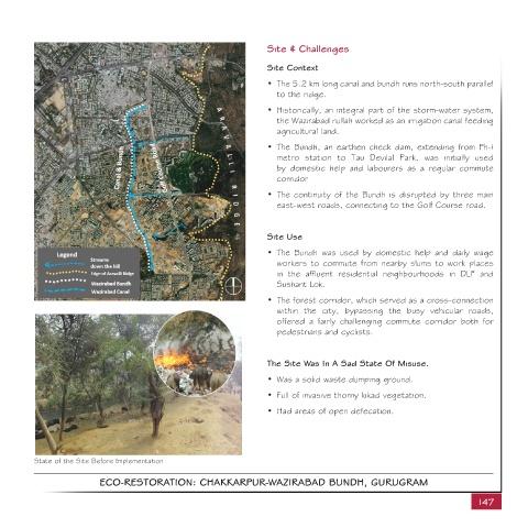
Site & Challenges


                                                                          Site Context
                                                                          •  The 5.2 km long canal and bundh runs north-south parallel
                                                                             to the ridge.

                                                                          •  Historically, an integral part of the storm-water system,
                                                                             the Wazirabad nullah worked as an irrigation canal feeding
                                                                             agricultural land.

                                                                          •  The Bundh, an earthen check dam, extending from Ph-I
                                                                             metro  station  to  Tau Devilal Park,  was initially used
                                                                             by domestic  help and labourers  as a regular  commute
                                                                             corridor
                                                                          •  The continuity of the Bundh is disrupted by three main
                                                                             east-west roads, connecting to the Golf Course road.


                                                                          Site Use

                                                                          •  The Bundh was used by domestic help and daily wage
                                                                             workers to commute from nearby slums to work places
                                                                             in  the  affluent  residential  neighbourhoods  in  DLF and
                                                                             Sushant Lok.
                                                                          •  The forest corridor, which served as a cross-connection
                                                                             within the city, bypassing the busy vehicular roads,
                                                                             offered a fairly challenging commute  corridor  both for
                                                                             pedestrians and cyclists.


                                                                          The Site Was In A Sad State Of Misuse.

                                                                          •  Was a solid waste dumping ground.
                                                                          •  Full of invasive thorny kikad vegetation.

                                                                          •  Had areas of open defecation.


          State of the Site Before Implementation

                            ECO-RESTORATION: CHAKKARPUR-WAZIRABAD BUNDH, GURUGRAM

                                                                                                                                    147