
Page 23 - HUDCO BEST PRACTICE AWARDS
P. 23
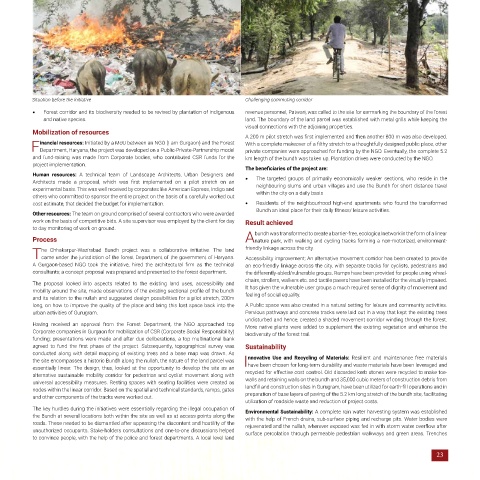
Situation before the initiative                                       Challenging commuting corridor
            •   Forest corridor and its biodiversity needed to be revived by plantation of indigenous   revenue personnel, Patwari, was called to the site for earmarking the boundary of the forest
               and native species.                                                land. The boundary of the land parcel was established with metal grills while keeping the
                                                                                  visual connections with the adjoining properties.
            Mobilization of resources
                                                                                  A 200 m pilot stretch was first implemented and then another 800 m was also developed.
              inancial resources: Initiated by a MoU between an NGO (I am Gurgaon) and the Forest   With a complete makeover of a filthy stretch to a thoughtfully designed public place, other
           FDepartment, Haryana, the project was developed on a Public-Private-Partnership model   private companies were approached for funding by the NGO. Eventually, the complete 5.2
            and fund-raising was made from Corporate bodies, who contributed CSR funds for the   km length of the bundh was taken up. Plantation drives were conducted by the NGO.
            project implementation.
                                                                                  The beneficiaries of the project are:
            Human  resources:  A technical team of Landscape Architects,  Urban  Designers and   The targeted  groups  of primarily  economically  weaker sections,  who reside  in  the
            Architects  made  a  proposal,  which  was  first  implemented  on  a  pilot  stretch  on  an   •   neighbouring slums and urban villages and use the Bundh for short distance travel
            experimental basis. This was well received by corporates like American Express, Indigo and   within the city on a daily basis
            others who committed to sponsor the entire project on the basis of a carefully worked out
            cost estimate, that decided the budget for implementation.            •   Residents of the  neighbourhood high-end  apartments  who  found the  transformed
                                                                                      Bundh an ideal place for their daily fitness/ leisure activities.
            Other resources: The team on ground comprised of several contractors who were awarded
            work on the basis of competitive bids. A site supervisor was employed by the client for day   Result achieved
            to day monitoring of work on ground.
                                                                                     bundh was transformed to create a barrier-free, ecological network in the form of a linear
            Process                                                               A  nature park, with walking and cycling tracks forming a non-motorized, environment-

               he Chhakarpur-Wazirabad Bundh project  was a collaborative initiative.  The land   friendly linkage across the city.
            Tcame under the jurisdiction of the forest Department of the government of Haryana.    Accessibility improvement: An alternative movement corridor has been created to provide
            A  Gurgaon-based  NGO  took  the  initiative,  hired  the  architectural  firm  as  the  technical   an eco-friendly linkage across the city, with separate tracks for cyclists, pedestrians and
            consultants; a concept proposal was prepared and presented to the forest department.   the differently-abled/vulnerable groups. Ramps have been provided for people using wheel-
                                                                                  chairs, strollers, walkers etc. and tactile pavers have been installed for the visually impaired.
            The proposal looked  into aspects related  to the existing  land uses,  accessibility  and   It has given the vulnerable user groups a much required sense of dignity of movement and
            mobility around the site, made observations of the existing sectional profile of the bundh   feeling of social equality.
            and its relation to the nullah and suggested design possibilities for a pilot stretch, 200m
            long, on how to improve the quality of the place and bring this lost space back into the   A Public space was also created in a natural setting for leisure and community activities.
            urban activities of Gurugram.                                         Pervious pathways and concrete tracks were laid out in a way that kept the existing trees
                                                                                  undisturbed and hence, created a shaded movement corridor winding through the forest.
            Having received  an approval from the Forest Department,  the NGO  approached  top   More native plants were added to supplement the existing vegetation and enhance the
            Corporate companies in Gurgaon for mobilization of CSR (Corporate Social Responsibility)   biodiversity of the forest trail.
            funding; presentations were made and after due deliberations, a top multinational bank
            agreed  to  fund  the  first  phase  of  the  project.  Subsequently,  topographical  survey  was   Sustainability
            conducted along with detail mapping of existing trees and a base map was drawn. As
            the site encompasses a historic Bundh along the nullah, the nature of the land parcel was   nnovative  Use and Recycling of  Materials: Resilient  and maintenance  free materials
            essentially  linear. The design,  thus,  looked at the opportunity  to develop the site  as an   Ihave been chosen for long-term durability and waste materials have been leveraged and
            alternative sustainable mobility corridor for pedestrian and cyclist movement along with   recycled for effective cost control. Old discarded kerb stones were recycled to make toe-
            universal accessibility measures. Resting spaces with seating facilities were created as   walls and retaining walls on the bundh and 35,000 cubic meters of construction debris from
            nodes within the linear corridor. Based on the spatial and technical standards, ramps, gates   landfill and construction sites in Gurugram, have been utilized for earth-fill operations and in
            and other components of the tracks were worked out.                   preparation of base layers of paving of the 5.2 km long stretch of the bundh site, facilitating
                                                                                  utilization of roadside waste and reduction of project costs.
            The key hurdles during the initiatives were essentially regarding the illegal occupation of   Environmental Sustainability: A complete rain water harvesting system was established
            the Bundh at several locations both within the site as well as at access points along the   with the help of French drains, sub-surface piping and recharge pits. Water bodies were
            roads. These needed to be dismantled after appeasing the discontent and hostility of the   rejuvenated and the nullah, wherever exposed was fed in with storm water overflow after
            unauthorized occupants. Stake-holders consultations and one-to-one discussions helped   surface percolation through permeable pedestrian walkways and green areas. Trenches
            to convince people, with the help of the police and forest departments. A local level land

                                                                                                                                                 23