
Page 23 - HUDCO-BPA21
P. 23
URBAN GOVERNANCE
TOPOGRAPHIC SURVEY AND CADASTRAL for integration of spatial database into a centralized bodies, greens, locality boundaries, pin codes etc.
system. A Geographical Informatics System (GIS) driven Ÿ Demarcation of boundaries of wards, Municipal
MAPPING OF ROHTAK TOWN USING GIS initiative was launched in 2014 with the establishment of Corporation schemes and Haryana Urban
a Geo Lab. Development Authority land.
- by Municipal Corporation Rohtak, Haryana
ESTABLISHMENT OF PRIORITIES: Data Collection and Validation:
All records related to town planning schemes, colonies, Ÿ Dedicated teams of 4 people working for the
he project has been executed by the Town Planning Wing of Rohtak Municipal Corporation (MCR). The controlled area of the Corporation and the plot numbers Corporation were involved in field surveys, total
Government of Haryana has designated Haryana Space Applications Center (HARSAC) as the nodal agency were stored physically. The utility network drawings and station surveys, and property verification.
Tfor generation of Geospatial Database using Remote Sensing and GIS State-of-the-Art technology. The details were kept manually in the department and people Ÿ Thereafter, property and khasra (land record) details
project has been executed by the Town Planning Wing of Rohtak Municipal Corporation (MCR) and was supported interested in real estate had to come to the municipal were integrated with the GIS database
by (HARSAC). Prior to 2014, the Corporation identified several complexities in ensuring effective implementation corporation for search of the sanctioned details of Ÿ Each plot was linked to House Index Data and
of its responsibilities due to a lack of spatial data. The initiative was launched with the establishment of a Geo Lab buildings. There was no particular geo-referenced base assigned a Unique Property Number.
on the 26th of January 2014. The Geo Lab was set up with the following objectives: map of Rohtak Town before the initiative. All budget Post the validation, the final map output was generated on the
proposals were monitored on the data available rather
Ÿ To preserve the legacy data, that were in physical form. centralized Geo Spatial Database of the MCR that
than spatially. This was leading to ineffective municipal
included Ward Boundary Maps, House Index Maps, Base
Ÿ Electronic storage of data that was in the form of print. governance. Thus, the need for more transparency and
Layer Maps, Approved/ Unapproved Maps, Customized Maps.
Ÿ To enable easy retrieval of data for the public and user departments by obtaining the drawing of land along accountability led to the conceptualization of the GIS
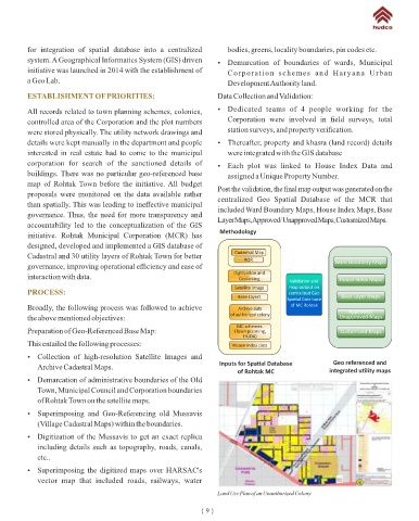
Methodology
with dimensions, area (as on ground and also as per House Tax Survey), other attributes and initiative. Rohtak Municipal Corporation (MCR) has
neighbourhood details. designed, developed and implemented a GIS database of
Cadastral Map
Ÿ Facilitate prompt updation of digital Property UID. Whenever there is a future updation, the survey can Cadastral and 30 utility layers of Rohtak Town for better ROR Ward Boundary Maps
promptly upload the data from the field Survey to the computer. governance, improving operational efficiency and ease of
Digi za on and
Ÿ Better resource planning and better monitoring of land encroachments of public/private properties using interaction with data. Geolinking Valida on and House Index Maps
map output on
Geospatial database and Geo-referenced satellite Image. PROCESS: Satellite Image centralized Geo
Base Layers Base Layer Maps
Spa al Data base
of MC Rohtak
Broadly, the following process was followed to achieve Archive data
of authorized colony Approved/
the above mentioned objectives: Unapproved Maps
KEY DATES: 1668.47 sq km. The population of the district as per the MC schemes
Preparation of Geo-Referenced Base Map: (Town planning, Customized Maps
2011 census is 1058683. The density of population is 466 HUDA)
Date Initiative per sq km. There are 146 villages and 151 Panchayats in This entailed the following processes: House Index data
26th January Initiation of Geo Lab the district. The rural population is 613864 and the urban Ÿ Collection of high-resolution Satellite Images and
2014 Inputs for Spa al Database Geo referenced and
Completion of digitization of revenue data, population is 444819. Archive Cadastral Maps. integrated u lity maps
house & street indexing, digitization of of Rohtak MC
municipal properties As per 2011 census, the rural population constitutes Ÿ Demarcation of administrative boundaries of the Old
Town, Municipal Council and Corporation boundaries
Launch of property tax portal linked with 57.98% of the total population of the district. The
digitized cadastral map of Rohtak Town on the satellite maps.
economy of the district is primarily agriculture i.e.
agrarian economy. About 51.89% of the total workers are Ÿ Superimposing and Geo-Referencing old Mussavis
BACKGROUND:
engaged in agriculture and allied activities, 7.68% in the (Village Cadastral Maps) within the boundaries.
The Rohtak district lies in the southeast of Haryana state. cottage & household industries and the rest are engaged in Ÿ Digitization of the Mussavis to get an exact replica
It is bound by Jind and Sonipat districts on the north, other activities. including details such as topography, roads, canals,
Jhajjar district on the south, Jhajjar and Sonipat district on etc..
After the successful implementation of Rehabilitation
the east and Hisar and Bhiwani districts on the west side.
Schemes, Town Planning Schemes and Improvement Ÿ Superimposing the digitized maps over HARSAC's
Area & Population- The district is having an area of Trust Schemes in Rohtak, it was felt that there was a need vector map that included roads, railways, water
Land Use Plan of an Unauthorized Colony
{ 8 } { 9 }